Wartime Co. Tyrone

In the Second World War, Co. Tyrone hosted troops from the United States Army as well as the newly-formed Belgian Infantry Brigades and a large airfield.

County Tyrone

Northern Ireland

Co. Tyrone takes its name from the old town name of Tír Eoghain, the Irish word for Eoghain's land, an area of Ulster ruled by the O'Neill's until the 17th Century. Covering an area of around 3,155 square kilometres, it shares borders with Co. Fermanagh to the south-west, Co. Londonderry to the north, and Co. Armagh to the south-east.

During the Second World War, troops established bases and trained in Ulster’s largest county. British, American, and Belgian military passed through Co. Tyrone during wartime with military bases in towns such as Omagh a large airfield at Ardboe.

Northamptonshire Regiment in Omagh, Co. Tyrone

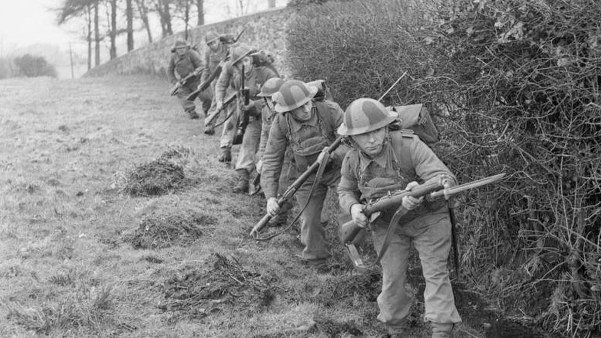
Imperial War Museum Photo: H 17112 (Part of the War Office Second World War Official Collection). A patrol from 4th Battalion, Northamptonshire Regiment advance warily alongside a hedge during training in Omagh, Co. Tyrone on 5th February 1942. Photo taken by Lieutenant JR Bainbridge - Official War Office Photographer.

Places of Interest

Map showing Ardboe, Co. Tyrone during the Second World War

Ardboe, Co. Tyrone during the Second World War

Co. Tyrone

Ardboe is a village in Co. Tyrone, Northern Ireland. It lies near Cookstown and was redveloped during the 1940s with the building of the Cluntoe Airfield.

Map showing Caledon, Co. Tyrone during the Second World War

Caledon, Co. Tyrone during the Second World War

Co. Tyrone

The village of Caledon, Co. Tyrone lies near the border of Co. Armagh. In the Second World War, it provided bases for British, American, and Belgian forces.

Map showing Dungannon, Co. Tyrone during the Second World War

Dungannon, Co. Tyrone during the Second World War

Co. Tyrone

The Second World War brought changes to rural mid-Ulster towns like Dungannon, Co. Tyrone with U.S Army, and German Prisoners of War becoming common sights.

Map showing Fintona, Co. Tyrone during the Second World War

Fintona, Co. Tyrone during the Second World War

Co. Tyrone

The small market village of Fintona, Co. Tyrone and neighbouring rural areas changed greatly between 1942 - 1944 with the arrival of the United States Army.

Map showing Fivemiletown, Co. Tyrone during the Second World War

Fivemiletown, Co. Tyrone during the Second World War

Co. Tyrone

The last train stopped in Fivemiletown, Co. Tyrone on 31st December 1941 as the Clogher Valley Railway ceased service for good during the Second World War.

Map showing Gortin, Co. Tyrone during the Second World War

Gortin, Co. Tyrone during the Second World War

Co. Tyrone

The Second World War brought the United States Military to the quiet mid-Ulster village of Gortin, Co. Tyrone as 34th Infantry Division arrived in 1942.

Map showing Omagh, Co. Tyrone during the Second World War

Omagh, Co. Tyrone during the Second World War

Co. Tyrone

Omagh, Co. Tyrone in the Second World War became a hub for the United States Military. From 1942, they had bases in castles, manors, and parks in the area.

Map showing Seskinore, Co. Tyrone during the Second World War

Seskinore, Co. Tyrone during the Second World War

Co. Tyrone

Seskinore, Co. Tyrone in the Second World War became an important distibution post with the arrival of Quartermaster Units of the US Army in November 1943.

References
  1. Wikipedia