Portadown, Co. Armagh during the Second World War

Throughout the Second World War in Portadown, Co. Armagh, locals became used to the sight of British, American, and Belgian troops and even German POWs.

Portadown

Co. Armagh

Northern Ireland

Throughout the Second World War, Portadown, Co. Armagh underwent many changes seeing the building of defensive structures along the line of the Bann River and the arrival of troops from Britain, American and even Belgium.

The town lies on the banks of the River Bann in the Armagh, Banbridge, and Craigavon Borough Council area. It is part of Craigavon along with Lurgan. The town was once known as The Hub Of The North. At 24 miles or 39km south-west of Belfast, it has links with the Northern Irish capital via the M1 motorway and a direct railway line. With transport via railways and the River Bann, it became an important centre for textile and linen production.

VE Day in Portadown, Co. Armagh

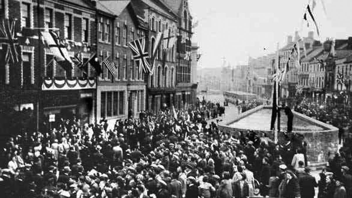
The VE Day celebrations in Portadown, Co. Armagh. Crowds gather outside St. Mark's Church from where you can see a water tank in the foreground and an air raid shelter further down the street. Photo from Portadown Photos.

American Forces

The following American forces were based in the Co. Armagh town between 1943 and 1944. If you have more information on exact bases, please get in touch.

Start Date End Date Unit
18/10/1943 22/12/1943 Company K, 467th Quartermaster Truck Regiment
22/12/1943 02/04/1944 3630th Quartermaster Truck Company (Heavy)
07/11/1943 06/06/1944 55th Finance Disbursing Section
11/1943 06/1944 19th Special Services Company (Minus)
24/12/1943 28/01/1944 Headquarters and Headquarters Detachment, 152nd Quartermaster Battalion (Mobile)
05/04/1944 06/05/1944 136th Quartermaster Truck Company (Nebraska National Guard)

Places of Interest

The following places will be of interest to anyone wishing to explore more of the area's Second World War heritage.

Map showing Armagh Road Presbyterian Church, Portadown, Co. Armagh

Armagh Road Presbyterian Church, Portadown, Co. Armagh

Church Street, Portadown, Co. Armagh

Armagh Road Presbyterian Church, Portadown, Co. Armagh welcomed members of the United States Army to a special service of gospel songs on 2nd April 1944.

Map showing Bann Bridge Air Raid Shelter, Portadown, Co. Armagh

Bann Bridge Air Raid Shelter, Portadown, Co. Armagh

Bridge Street, Portadown, Co. Armagh

Contractors discovered an air-raid shelter dating from the early 1940s beneath the Bann Bridge in Portadown in 2005. It is a rare find in Northern Ireland.

Map showing Bleary Pillbox, Portadown, Co. Armagh

Bleary Pillbox, Portadown, Co. Armagh

Cranny Road, Portadown, Co. Armagh

The Bleary Pillbox is similar in construction to nearby structures at Drumlin Hill, Moyallan. It is one of seven pillboxes in the town making up defences along the River Bann.

Map showing Brownstown Prisoner of War Camp, Portadown, Co. Armagh

Brownstown Prisoner of War Camp, Portadown, Co. Armagh

Fitzroy Street, Portadown, Co. Armagh

Camp 11a, the Brownstown Prisoner of War Camp, was lost beneath redevelopment of the Brownstown Estate in the 1960s but residents remember German inmates.

Map showing Carrickblacker Prisoner of War Camp, Portadown, Co. Armagh

Carrickblacker Prisoner of War Camp, Portadown, Co. Armagh

192 Gilford Road, Portadown, Co. Armagh

Portadown Golf Club was once the site of a grand house and the Carrickblacker Prisoner of War Camp, which took its name from the 17th century mansion.

Map showing Drumcree Church of Ireland, Portadown, Co. Armagh

Drumcree Church of Ireland, Portadown, Co. Armagh

78 Drumcree Road, Portadown, Co. Armagh

Drumcree Church of Ireland churchyard in Portadown, Co. Armagh contains five Commonwealth War Graves dating from World War Two between 1940 and 1946.

Map showing Killicomaine Prisoner of War Camp, Portadown, Co. Armagh

Killicomaine Prisoner of War Camp, Portadown, Co. Armagh

Killicomaine Road, Portadown, Co. Armagh

The Killicomaine Prisoner of War Camp stood on the grounds of Killicomaine Castle or Irwin's Castle running onto Collen's Lane, now called Princess Way.

Map showing Moyallan Pillbox, Portadown, Co. Armagh

Moyallan Pillbox, Portadown, Co. Armagh

Gilford Road, Portadown, Co. Armagh

The Moyallan Pillbox remains standing on a crest overlooking the River Bann defensive line in the townland of Moyallan between Portadown in Co. Armagh and Gilford in Co. Down.

Map showing Seagoe Cemetery, Portadown, Co. Armagh

Seagoe Cemetery, Portadown, Co. Armagh

59 Seagoe Road, Portadown, Co. Armagh

Seagoe Cemetery in the Co. Armagh town of Portadown contains fourteen Commonwealth War Graves relating to World War Two dating between 1940 and 1946.

Map showing The Plaza Ballroom, Portadown, Co. Armagh

The Plaza Ballroom, Portadown, Co. Armagh

Bridge Street, Portadown, Co. Armagh

The old Plaza Ballroom building on Bridge Street, Portadown has had many uses; in recent times a funeral parlour but in the 1940s, it was full of life.